UPDATE: 1 New Fire Reported West of Helena
HAVRE -- Firefighters continue to make progress on the Eagle Creek Fire, doubling the estimated containment to 40%, while reducing the estimated size to 7,225 acres. The fire is 30 miles south of Havre, in the Bears Paw Mountains.
The Eagle Creek fire burned actively within the fire perimeter on Sunday, September 11th. The fire burned most actively in the southwestern corner of the fire within containment lines. Air and ground resources actively engaged the active interior portion of the fire and continued mop up of the fire perimeter. 234 personnel are assigned to the fire for the difficult task of moping up indirect fire line.
The Lions Campground and Sandy Creek Campground remain closed until further notice. Emergency and local traffic only on Beaver Creek Road above Upper Bear Paw Lake.
The cause of the fire, which broke out last Wednesday afternoon, has not been determined.
----------------------
HELENA -- A new fire was reported on Sunday, September 11. The No Grass Creek fire is located in Powell County on the west end of the Helena Ranger District of the Helena-Lewis & Clark National Forest.. The fire is in/around Blackfoot Meadows; last estimate was around 400 acres. It is in the Electric Peak Inventoried Roadless Area and is not threatening any homes or private property at this time.
-------------------
GLACIER NATIONAL PARK -- There's been no change in status for the Quartz and North Camas Fires.
The Quartz Fire continues to consume dead and down heavy fuels within its perimeter. The Quartz Fire is estimated to be 1981 acres. A squad remains staged at the Quartz Lake Cabin reinforcing structure protection and patrolling the Quartz Fire.
The North Camas Fire continues burning in very steep, inaccessible terrain and is estimated at 20 acres. The fire is not currently threatening any structures, park resources, nor the public.
-----------------------
BOB MARSHALL WILDERNESS -- The George Lake Fire is burning on the bottom of the slope at the northeast end of George Lake. The fire gained just 10 acres over the weekend, and is estimated at 537 acres as of midday Sunday. The Spotted Bear Ranger District will continue to monitor the fire with reconnaissance and Infrared (IR) Mapping flights as resources allow. Due to the rocky terrain and lack of available fuels, no other actions are planned at this time.
The Ursus Fire is still listed at 1,824 acres. The Ursus Fire has has reached the 2012 Elbow Pass burn scar which should act as a buffer to slow the spread of the fire to the east.
The 1872-acre Cannon Fire, which is located 15 miles northeast of Condon. There is a significant fire history in the surrounding area that will affect fire spread.
The Dean Creek Fire, 30 miles east of Swan Lake, has been holding at 483 acres since last Wednesday morning. Fire activity was described as "minimal" over the weekend.
-------------------
MARION -- The lightning-caused Lemonade Fire grew a little over the weekend, and this morning was estimated at 667 acres, but firefighters also made headway, and report 45% containment.
The fire is in the Flathead National Forest, 21 miles west of Kalispell.
Over the next few days, fire managers will begin strategically releasing resources to align with current firefighting needs. However, work continues as crews hot spot, cool the fire's edge, mitigate hazard trees, and begin pulling hose and equipment no longer needed.
------------------
HELMVILLE -- Firefighters continue to increase containment of the Murray Fire, 12 miles SW of Helmsville, reaching 65% as of Monday morning. Fire crews are initiating mop up activities where safe and possible to do so. Fire activity was minimal again today, with just a few hot spots smoldering in the very interior of the fire area. Crews have worked hard to dig and reinforce hand line and lay hose to contain and suppress the fire. Aircraft is primarily being used to shuttle equipment, cargo, and firefighters to and from the spike camp in the fire area, as well as conduct mapping missions. The steep and rocky terrain has proved challenging for crews and equipment, but they have done an excellent job building and maintaining access to the fire area.
-----------------------------
LIBBY -- The Bull Gin Complex, a group of four wildfires in the Kootenai National Forest, nearly doubled over thew weekend, and now covers a total of 3047 acres.
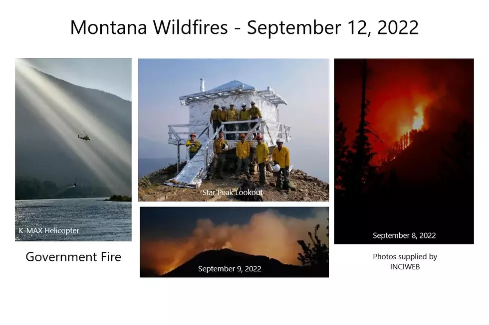
The Government Fire, 2 miles northeast of Noxon, is listed at 1791 acres. Handcrews, engines, and skidgines successfully held the fire at control lines on the west side in the Government Creek area; mitigating trees falling over the control line and utilizing water to cool the fire’s edge. On the east side, as the fire approaches the Rock Creek drainage, vegetation removal along control lines is ongoing as firefighters and heavy equipment reduce the fuels along the road system. Construction of the dozer line to the south of the fire and north of residences on Government Mountain Road is complete. Handcrews will clean up the dozer line removing snags and other fuels as necessary and install hose lays to ensure water is available on the line. Night operations are in place with engines monitoring fire spread to the south and attending to trees that fall over the control line on the west end of the fire.
Firefighters on the three-acre fire Rock Lake Fire will ensure the perimeter is secure and there are no areas of heat near the fire edge.
Two miles northeast of Heron, the Billiard Fire covers 992 acres. The northwest side of the fire is holding along constructed dozer and handline, northeast of Fatman Mountain. Water systems including hoses, sprinklers, pumps, and portable water tanks are in place for all structures along Blue Creek, Blue Creek Bay, Hillside Lane, and Fatman Road.
The Isabella Lake Fire is 264 acres, and is in rough inaccessible terrain in the Cabinet Mountains Wilderness. The fire is being monitored by air.
-----------------------------
MISSOULA -- The Boulder Lake Fire is now approximately 1,700 acres in size due to fire growth on the south flank of the fire. Fire behavior on the south flank includes surface fire with isolated single tree torching, short-range spotting, and creeping in heavy dead and down fuels with a high concentration of overhead hazards. The Gold Creek cabin remains unburned. Point protection of the cabin will continue as needed using helicopter bucket drops to check any fire spread toward the cabin.
Heavy equipment is operating south of the fire working to improve existing roads for access and control lines. Today, multiple helicopters will work to conduct water bucket drops along the south flank to check fire spread and moderate fire activity in coordination with firefighters on the ground. MT DNRC engines continue to seek out and extinguish spot fires on the north flank of the fire near the Gold Creek Trailhead.
Fire managers continue to utilize a confine and contain suppression strategy to engage the south and eastern flanks of the fire, outside of the Wilderness boundary.
-----------------------------
MONARCH -- The Deep Creek Fire, in the northeast corner of the Little Belt Mountains, has been downsized from 75 acres to 37 acres, and is 70% contained. There has been no smoke visible for several days, now.
-------------------
SULA -- The Trail Ridge Fire is burning about 0.25 miles away from the Continental Divide Trail (CDT), 5 miles SE of Sula, MT and 11 miles NW of Big Hole National Battlefield. As of Monday morning, it is 15,008 acres
The fire is burning in a remote, rugged area of the 2000 Mussigbrod Fire burned area, with abundant standing dead trees and heavy ground fuels, as a result of that incident. There is a large amount of deadfall on the ground with numerous snags throughout the area, making it unsafe for firefighters to tackle it head-on.
Yesterday most of the fire’s growth was on the north flank of the fire with a large portion of that growth in Tolan Creek Drainage. Crews continue to move east from Mink Creek Road to the 2017 Myers Fire burn scar with construction of indirect line and road prep to be prepared for future fire growth if the fire continues to move to the northeast. If the fire does progress past the Tolan Creek Drainage and begins to threaten a breach along the East Fork Road to the south the Ravalli County Sheriff’s Department along with Fire Managers would implement the ‘Warning’ stage of the Evacuation Plan.
-------------------------
More From KSEN AM 1150


