UPDATE: No New Fires to Report Today! (So Far)
HAVRE -- Firefighters continue to make progress on the 7,225 acre Eagle Creek Fire, is 40%, contained. The fire is 30 miles south of Havre, in the Bears Paw Mountains. There have been no updates posted in the past 24 hours.
The Lions Campground and Sandy Creek Campground remain closed until further notice. Emergency and local traffic only on Beaver Creek Road above Upper Bear Paw Lake.
The cause of the fire, which broke out last Wednesday afternoon, has not been determined.
----------------------
HELENA -- The No Grass Creek Fire is located in Powell County on the west end of the Helena Ranger District of the Helena-Lewis&Clark National Forest The fire was initially sized up at 50-100 acres on the afternoon of Sunday, September 11, 2022, but has grown to 1004 acres. The No Grass Creek fire is located in an that has experienced large amounts of tree mortality. The fuel loading is dense, and because of the current state of the dead timber, it’s neither safe nor effective to put fire personnel into the area. Fire personnel are managing from the air, while other firefighters are observing the fire’s progression, activity and overall behavior within the planning area from various vantage points on the District. Due to the remote location, no homes or private property are threatened by the fire, which provides an opportunity to responsibly allow fire to naturally function and provide ecological benefits.
-------------------
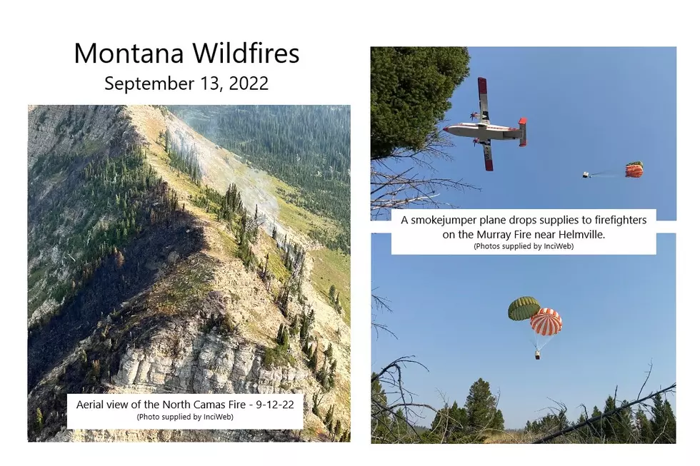
GLACIER NATIONAL PARK -- There's been no change in status for the Quartz Fire, while the North Camas Fire has grown some in recent days..
The Quartz Fire continues to consume dead and down heavy fuels within its perimeter. The Quartz Fire is estimated to be 1981 acres. A squad remains staged at the Quartz Lake Cabin reinforcing structure protection and patrolling the Quartz Fire.
The North Camas Fire continues burning in very steep, inaccessible terrain and is estimated at 71 acres as of Tuesday, Sept. 12.. The fire is not currently threatening any structures, park resources, nor the public.
-----------------------
BOB MARSHALL WILDERNESS -- The George Lake Fire is burning on the bottom of the slope at the northeast end of George Lake, located in the Bob Marshall Wilderness. As of 9/12/2022, the fire is 625 acres; and increase of nearly 100 acres since Sunday. Reconnaissance and Infrared (IR) Mapping flights will monitor the fire as resources allow. Due to the rocky terrain and lack of available fuels, no other actions are planned at this time.
The Ursus Fire originally showed primary growth to the east, but it has since reached the 2012 Elbow Pass burn scar which should act as a buffer to slow the spread of the fire in that direction. As of 9/12/2022, the fire has steadily grown along the north and south flanks in heavy timber.
The 1872-acre Cannon Fire, which is located 15 miles northeast of Condon. There is a significant fire history in the surrounding area that will affect fire spread.
The Dean Creek Fire, 30 miles east of Swan Lake, has been holding at 483 acres since last Wednesday morning. Fire activity is described as "minimal".
-------------------
MARION -- The lightning-caused Lemonade Fire has not grown over the past 24 hours. It remains estimated at 667 acres, and incident commanders report 60% containment.
The fire is in the Flathead National Forest, 21 miles west of Kalispell.
Fire managers have begun releasing some of the 234 firefighters and equipment to be reassigned to other fires, while mop-up continues on this one. Firefighters continue to look for hot spots, cool the fire's edge, and mitigate hazard trees.
Yesterday there was a spot fire across the fireline on the western perimeter. Firefighters caught it at less than an acre, and crews will further secure it today.
------------------
HELMVILLE -- Firefighters continue to increase containment of the Murray Fire, 12 miles SW of Helmsville, reaching 83% as of Tuesday morning. Fire activity was minimal again on Monday, Sept. 12, with smoldering hot spots in the interior of the fire area. Fire crews continue mop up activities as they reinforce hand lines in the rough, rocky terrain. As containment increases, demobilization of resources no longer needed for operations, such as heavy equipment and some personnel, will continue throughout the week. Aircraft are now primarily used to shuttle equipment, cargo, and firefighters to and from the spike camp in the fire area. Unless significant activity occurs the fire will transition back to the local unit this week. There are no evacuations in effect, and roads in the fire area are open only to local traffic for firefighter and public safety. Bow hunters and other public land enthusiasts are asked to stay clear of the area while firefighting activity is underway.
-----------------------------
LIBBY -- The Bull Gin Complex, a group of four wildfires in the Kootenai National Forest, covers a total of 3047 acres.
The Government Fire, 2 miles northeast of Noxon, is listed at 1791 acres. On the west side of the fire, in the Government Creek area, the fire slowly burned to the control lines, allowing firefighters to clear trees as they fall over the control line and utilize water to cool the fire’s edge. On the east side, heavy equipment crews work towards each other from the north and south, to connect a fuel break along the Rock Creek drainage. Masticators are mulching vegetation along the control lines to reduce fuels along the east side of the line. Crews will complete installation of hose lays north of residences and south of the fire from Government Mountain Road to Rock Creek Roads today, where residents are on pre-evacuation notice.
Heat remains interior on the three-acre Rock Lake Fire. The perimeter is secure and firefighters will begin to remove water handling systems.
Two miles northeast of Heron, the Billiard Fire covers 992 acres. Firefighters successfully implemented small firing operations along the 2290 road to consume fuels between the control line and the main fire. Crews quickly extinguished small spot fires that appeared on the northwest side of the fire. A dozer opened the 2293 road to serve as a check-line as the fire moved south. Water systems including hoses, sprinklers, pumps, and portable water tanks are in place for all structures along Blue Creek, Blue Creek Bay, Hillside Lane, and Fatman Road.
The Isabella Lake Fire is 264 acres, and is in rough inaccessible terrain in the Cabinet Mountains Wilderness. The fire is being monitored by air.
-----------------------------
MISSOULA -- The Boulder Lake Fire is now approximately 1,700 acres in size due to fire growth on the south flank of the fire. Fire behavior on the south flank includes surface fire with isolated single tree torching, short-range spotting, and creeping in heavy dead and down fuels with a high concentration of overhead hazards. MT DNRC engines continue to seek out and extinguish spot fires on the north flank of the fire near the Gold Creek Trailhead.
-----------------------------
SULA -- The Trail Ridge Fire, is burning about 0.25 miles away from the Continental Divide Trail (CDT), 5 miles SE of Sula, MT and 11 miles NW of Big Hole National Battlefield. It continues to grow, and as of Tuesday morning, it is 17,043 acres
The fire is burning in a remote, rugged area of the 2000 Mussigbrod Fire burned area, with abundant standing dead trees and heavy ground fuels, as a result of that incident. There is a large amount of deadfall on the ground with numerous snags throughout the area, making it unsafe for firefighters to tackle it head-on.
The fire movement observed remains within the indirect containment lines crews have been working on over the last week. The last few days the option for a back burn operation was heavily considered, and is still an option, but at this time crews continue to monitor the fire’s behavior and movement to wait for the most favorable time and location to initiate a back burn. Yesterday as the fire reached the Action Point personnel did not initiate the back burn operation due to adverse winds. The incoming moisture and decreased temperatures will help slow fire activity and creates unfavorable conditions for this back burn operation. Crews continue to work on indirect line construction and road prep along the fire’s perimeter moving toward the 2017 Myers Fire burn area to increase containment lines along the northern flank.
More From KSEN AM 1150


