UPDATE: Thompson Creek Fire 100% Contained; New Fire Reported Near Ennis
DILLON -- A 174-acre wildfire has been confirmed in the Gravelly Mountain Range. The Sunrise Fire is located south of Ennis, on the Madison District of the Beaverhead-Deerlodge National Forest and private land. The cause has not been determined.
Top priority for firefighters is to secure the fire edge on private land and are monitoring the Sunrise Fire's north and east edge today. Fire crews are also assessing for any fence damage along the BDNF Forest and private land boundary. The southwest edge of the fire was the primary source of heat yesterday, so crews are also working to identify and break up hotspots as they secure the west flank of this fire.
---------------------
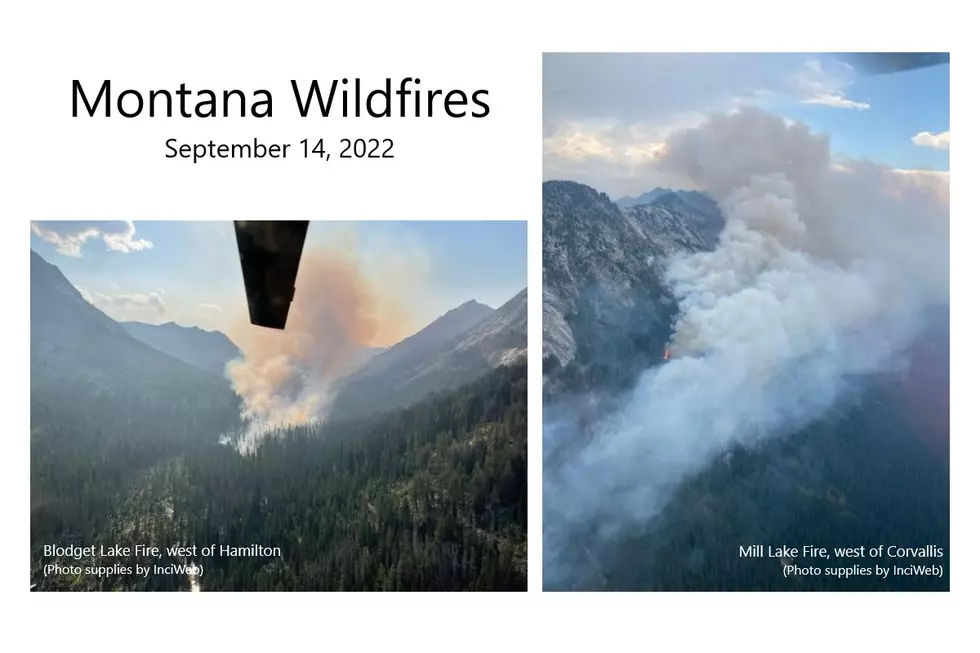
CORVALLIS -- The Mill Lake Fire continues to burn on 1608 acres of heavy timber in the Mill Canyon, west of Corvallis. Pushed by strong westerly winds, the fire made a one mile run with spotting occurring up to 3/4 mile ahead of the main fire. The steep and rugged terrain combined with the presence of snag trees, limits the ability to safely place firefighters directly on the fire at this time.
----------------------
HAMILTON -- Nearby is the Blodgett Lake fire, 10 miles west of Hamilton. 50 firefighters and 4 engines are on the scene, and the fire is estimated at 1200 acres, fed by heavy dead and down trees and cured shrubs between avalanche chutes.
Both fires are blamed on lightning strikes in late August. .A Type 1 incident management team took over management of the Mill Lake Fire and the Blodgett Lake Fire this morning.
---------------------
HAVRE -- Firefighters continue to make progress on the 7,225 acre Eagle Creek Fire, which has not grown in the past 24 hours, and as of Tuesday evening, is 60%, contained. The fire is 30 miles south of Havre, on the south slope of Baldy Mountain in the Bears Paw Mountains.
The Lions Campground and Sandy Creek Campground remain closed until further notice. Emergency and local traffic only on Beaver Creek Road above Upper Bear Paw Lake.
The cause of the fire, which broke out Wednesday afternoon, September 7, has not been determined.
----------------------
HELENA -- The No Grass Creek Fire is located in Powell County on the west end of the Helena Ranger District of the Helena-Lewis&Clark National Forest The fire was initially sized up at 50-100 acres on the afternoon of Sunday, September 11, 2022, but has grown to 1004 acres. The No Grass Creek fire is located in an that has experienced large amounts of tree mortality. The fuel loading is dense, and because of the current state of the dead timber, it’s neither safe nor effective to put fire personnel into the area. Fire personnel are managing from the air, while other firefighters are observing the fire’s progression, activity and overall behavior within the planning area from various vantage points on the District. Due to the remote location, no homes or private property are threatened by the fire, which provides an opportunity to responsibly allow fire to naturally function and provide ecological benefits.
-------------------
GLACIER NATIONAL PARK -- There's been no change in status for the Quartz Fire and the North Camas Fire..
The Quartz Fire continues to consume dead and down heavy fuels within its perimeter. The Quartz Fire is estimated to be 1981 acres. A squad remains staged at the Quartz Lake Cabin reinforcing structure protection and patrolling the Quartz Fire.
The North Camas Fire continues burning in very steep, inaccessible terrain and is estimated at 71 acres as of Tuesday, Sept. 12.. The fire is not currently threatening any structures, park resources, nor the public.
-----------------------
BOB MARSHALL WILDERNESS -- There are no new updates regarding the four fires burning in the Bob Marshall Wilderness.
The George Lake Fire is burning on the bottom of the slope at the northeast end of George Lake, located in the Bob Marshall Wilderness. As of 9/12/2022, the fire is 625 acres. Reconnaissance and Infrared (IR) Mapping flights will monitor the fire as resources allow. Due to the rocky terrain and lack of available fuels, no other actions are planned at this time.
The Ursus Fire originally showed primary growth to the east, but it has since reached the 2012 Elbow Pass burn scar which should act as a buffer to slow the spread of the fire in that direction.The fire has steadily grown along the north and south flanks in heavy timber, and now covers 4714 Acres.
The 1872-acre Cannon Fire, which is located 15 miles northeast of Condon. There is a significant fire history in the surrounding area that will affect fire spread.
The Dean Creek Fire, 30 miles east of Swan Lake, has been holding at 483 acres since last Wednesday morning. Fire activity is described as "minimal".
-------------------
MARION -- The lightning-caused Lemonade Fire has not grown over the past 48 hours. It remains estimated at 667 acres, and incident commanders report 90% containment.
The fire is in the Flathead National Forest, 21 miles west of Kalispell. Firefighters continue to look for hot spots, cool the fire's edge, and mitigate hazard trees.
------------------
HELMVILLE -- Firefighters continue to increase containment of the Murray Fire, 12 miles SW of Helmsville, reaching 93% as of Wednesday morning. With minimal fire activity, cooler temperatures, higher relative humidity and precipitation in the forecast, all conducive to fire containment, crews are aiming for 100% containment by Thursday, September 15. Fire crews continue demobilization of personnel and packaging up fire equipment no longer needed on the fire. They will continue this process until the fire is fully contained and the area is safe enough to be managed by the local fire unit.
-----------------------------
LIBBY -- The Bull Gin Complex, a group of four wildfires in the Kootenai National Forest, covers a total of 3673 acres.
The Government Fire, 2 miles northeast of Noxon, is listed at 2284 acres. The fire perimeter has grown slowly to the north, and towards control lines to the south and east. Yesterday, firefighters and engine crews successfully held control line on the west side, using available water resources and mitigating trees as they fell across the fireline. Firing operations were implemented to remove unburnt fuel between the control line and fire edge in the Government Creek area with both aerial and on-the-ground resources. The southwest edge of the fire slowly backed down to the dozer line. Crews and heavy equipment will continue mastication and chipping along on the 150 road in Rock Creek area, removing heavy fuels from the east side of the road. Night operations consisting of engines and a firefighting module patrolled Government Creek Road and the southern control line.
The Rock Lake Fire perimeter is secure; firefighters will backhaul unneeded equipment and check on interior smokes.
Two miles northeast of Heron, the Billiard Fire is now acres, a 200-acre increase since Tuesday. . Yesterday, firefighters held control line along the western edge of the fire and began working interior to further secure the line. Heavy equipment continued fuel removal efforts along Fatman Road. Hand crews and heavy equipment will remove slash on the 2293 road and begin constructing dozer line from top of the 2293 road down slope to Fatman Road. Water systems including hoses, sprinklers, pumps, and portable water tanks are in place for all structures along Blue Creek, Blue Creek Bay, Hillside Lane, and Fatman Road.
The Isabella Lake Fire has grown to 277 acres, and is in rough inaccessible terrain in the Cabinet Mountains Wilderness. The fire is being monitored by air.
-----------------------------
MISSOULA -- The Boulder Lake Fire is now approximately 1,800 acres in size. Crews are working hard to keep the fire in check and limit spread onto National Forest lands outside of the Wilderness that are under MT DNRC protection. MT DNRC engines continue to seek out and extinguish spot fires on the east flank of the fire and direct water bucket drops on the south flank of the fire to protect the Gold Creek cabin. Heavy machinery is improving existing roads to the south and east of the fire for improved access and use as control lines.
-----------------------------
MISSOULA -- Over the past few days, the Solomon Fire, southeast of Missoula, grew by approximately 30 acres and is now estimated to be 434 acres in size. The fire continues to exhibit moderate fire behavior, primarily on the eastern and the northern flanks of the fire. The fire continues to slowly burn in the main bowl below Solomon Mountain (at approximately 6,800 feet in elevation), burning through the heavy dead and down fuel. Firefighters are anticipating cooler weather and higher humidity for the rest of the week (9/13- 9/16) and into the weekend which will help to moderate fire behavior.
The fire will continue to smolder and light smoke may be visible until a season-ending event occurs which is either substantial rain or snowfall. Firefighters will continue to patrol the fire from the Rock Creek corridor and the air until substantial precipitation falls on the fire area. A helicopter may be used as needed to check fire spread. The terrain, fuel type, and the presence of snag trees limit the ability to place firefighters directly on the fire. No structures or infrastructure are currently threatened.
-----------------------------
SULA -- The Trail Ridge Fire, is burning about 0.25 miles away from the Continental Divide Trail (CDT), 5 miles SE of Sula, MT and 11 miles NW of Big Hole National Battlefield. It continues to grow, and as of Wednesday morning, it is holding at 17,043 acres.
The fire is burning in a remote, rugged area of the 2000 Mussigbrod Fire burned area, with abundant standing dead trees and heavy ground fuels, as a result of that incident. There is a large amount of deadfall on the ground with numerous snags throughout the area, making it unsafe for firefighters to tackle it head-on.
The fire experienced just under 0.20 inches of precipitation during the day which helped to moderate fire behavior and slow the fire’s spread. The northern flank of the fire remains near Mink Creek Saddle and Shultz Saddle Road at this time and is still within indirect containment lines that have been established. Crews continue to work on road prep and indirect line along the Meadow Creek Road area.
On the southern flank of the fire there was minimal growth and crews are nearing completion on indirect line in this area. The fire continues to move south toward the 2007 Rat Creek and 2021 Trail Creek Burn Areas. The southern flank of the fire had minimal growth and at this time Hogan Cabin remains closed for reservations as a precaution due to the proximity of the fire. An IR flight was conducted over night and minimal heat was detected across the fire area.
The fire is still within containment lines and has not reached the Action Point identified for the ‘Warning’ stage of the Evacuation Plan at this time. As the fire nears this Action Point, Fire Managers and the Ravalli County Sheriff’s Department are prepared for the possibility of moving into this ‘Warning’ stage, although, this is unlikely at this time.
Meanwhile, the Thompson Creek Fire, 19 miles east of Sula has been 100% contained at 85 acres. Over the last few days aircraft has been helpful in removing all equipment and supplies off the road area of the fire. The majority of personnel hiked off of the fire yesterday and the remainder of personnel will be hiking out today. The fire has been put in ‘Patrol’ status.
More From KSEN AM 1150