Firefighters Continue to Slowly Gain Ground on Montana Wildfires
Here is the latest on the major fires burning in Montana, as of noon on Friday, August 11, 2023.
RIDGE FIRE
The 2940-acre Ridge Fire is located 6 miles southeast of Hungry Horse, MT on the Hungry Horse Ranger District of the Flathead National Forest. The Ridge Fire is a full suppression fire and firefighters responded quickly using indirect tactics by creating fuel breaks along existing roads and natural features.
The Hungry Horse Reservoir is closed to all public access, including both the east and west side roads. As firefighting efforts continue on the Ridge Fire, the Tin Soldier Complex, and other fires in the area, the closure is in place to provide for public and firefighter safety.
Yesterday, at the southern edge of the fire near Emery Creek crews mopped up along the roadway and continued direct handline up to the 1616 Road. Additional handline was constructed connecting the road system, and a proposed dozer line will continue to the 38 Road. At the northwest corner two Hotshot Crews scouted the area and developed a plan to go direct on the fire’s edge and continue handline to the south. To the north resources scouted the area for potential opportunities, and on the eastern side aviation resources were utilized to keep the fire in its current footprint.
Today, crews will continue direct line from the south to the 590E Road and construct direct line on the west side of the fire to Desert Mountain Ridge. A plan will also be developed for the possibility of strategic low intensity firing operations where needed to safely connect area of the fireline. Structure protection assessments continue and are coordinated with the local agencies.
Today’s weather is forecast to be mostly sunny with a maximum temperature of 80-85 degrees, minimum relative humidity 21- 26% at lower elevations, and west winds 6-12 mph with afternoon gusts around 16 mph.
PRE-EVACUATION NOTICE: The Flathead County Sheriff’s Office has issued a pre-evacuation notice from the east side of Spotted Bear Road to West Glacier. EMERGENCY SHELTER: The American Red Cross has set up an emergency shelter at the Columbia Falls Junior High School (1805 Talbot Road Columbia Falls, MT) for residents affected by the Ridge Fire. Those who plan to use the emergency shelter are asked to call 1-800-733-2767 prior to arrival.
SIDNEY FIRE
There has been no change reported in the status of the Sidney Fire, which is 12 miles south of East Glacier and 16-miles west of Heart Butte, in the northwest tip of the Pondera County panhandle. An IR flight conducted on Sunday (Aug. 6) showed the fire is 49 acres in size, and burning near footprints from fires in 2007 and 2017, which is aiding firefighters, since fuels in these footprints are less dense.
The following trails are currently closed due to fire activity:
- Trail 101 from the junction of 101 and 133.
- Trails 133, from Summit Trailhead, and Trail 133.1, from -Summit Campground, to where these 2 trails join Trail 137.
- Trail 134 from Forest Road 8958 to the junction with Trail 137.
- Trail 137 from the Trail 133/133.1 junction to the Trail 137/101 junction.
- TTrail 136 which runs between Trails 101 and 137.
ROGERS PASS FIRE
This lightning-caused fire, 15-miles east of Lincoln, received about an inch of rainfall over the weekend. As of Sunday evening, it was still 46 acres, and 50% contained. The Continental Divide Trail has been reopened.
COLT FIRE
An unmanned aerial system (UAS) was able to pinpoint areas of heat within the 7,207-acre fire’s southwestern edge that firefighters were unable to see from the ground. This data will assist operations staff in making informed, strategic decisions regarding future firefighting action on the ground.
The fire is 45% contained. Crews continue to mop-up areas of residual heat along the fire’s north and south perimeters. Heavy equipment assisted crews on the southern end of the fire with line construction. Heavy equipment continues to improve existing roads in the fire area to allow for better firefighter access to the fire’s southern flank. Crews will spend the next few days completing handline on the southwest edge of the fire. Once the handline is completed, crews plan to begin the mop-up process in the area. In order to facilitate this effort, a helicopter crew brought supplies (such as hose lays and pumps) into the southwest area of the fire.
Temperatures began to rise in the fire area on Thursday, as relative humidity began to drop into the 30s. This trend is likely to continue in the coming days, increasing the risk of more active fire behavior. Currently, the fire is mainly burning in dead standing or downed trees, however, as fuels dry out it is expected that other fuels, such as huckleberry bushes and other shrubs, may ignite more readily.
NIARADA FIRE & MILL POCKET FIRE
MIDDLE RIDGE FIRE
West of Ronan, is still estimated at 12,700 acres, 12,700 acres, and is 75% contained, as of Wednesday, August 8th .Smoke may still be visible interior of the fire containment line where the fire is still smoldering.
HOLMES CREEK FIRE
The Confederated Salish & Kootenai Tribes Division of Fire reports the Holmes Creek Fire is 45 acres and 70% contained, burning in steep, rocky terrain on top of the Mission Mountain Range. Smokejumpers and heli-repellers have been working the fire.
BIG KNIFE FIRE
Weather in the vicinity of this 4952-acre blaze is becoming warmer and fuels are beginning to dry out again. Historically, fire seasons often persist until early fall in this area. As a result, fire managers are evaluating the long-term potential fire growth of the Big Knife Fire.
Heavy equipment operators continue to tie road prisms into constructed firelines along the fire’s southwestern perimeter. Crews continue assessing and implementing point protection measures to protect infrastructure and cultural resources identified by Resource Advisors. Firefighters are mopping up the edge of a strategic firing operation they conducted late last week to keep the fire north of Agency Creek. Aircraft are aiding firefighters as conditions allow, and helicopters dropped water on hot spots in the Agency Creek drainage.
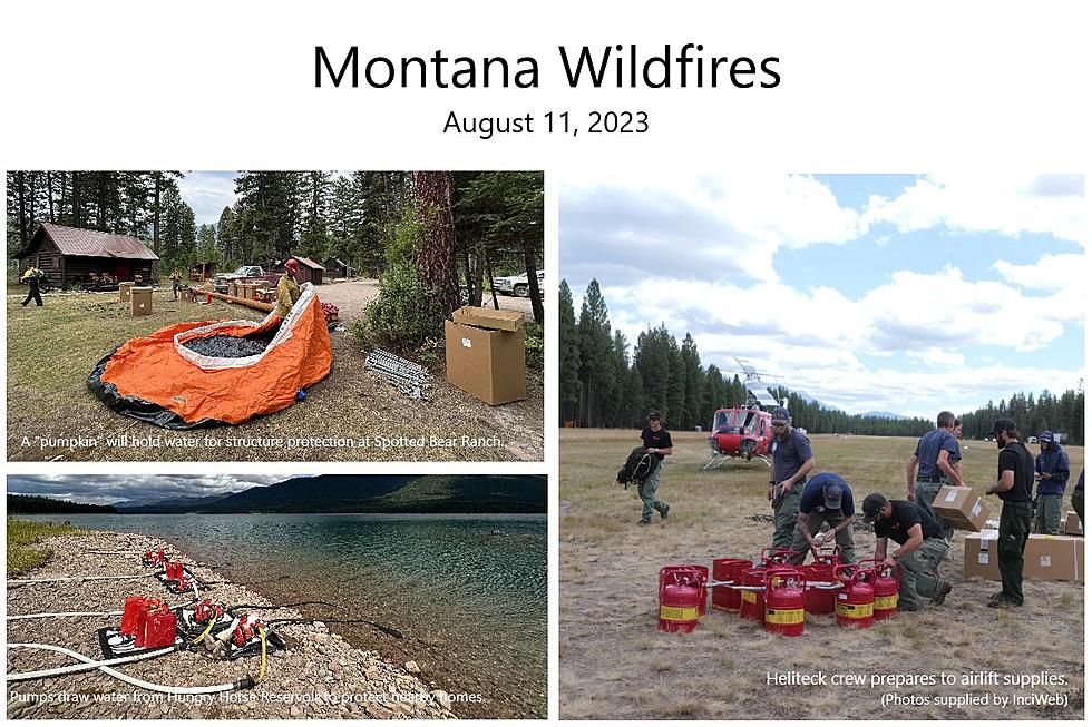
TIN SOLDIER COMPLEX
Hungry Horse Reservoir remains closed to the public. All National Forest System lands in the area and FS Road #38 (East Side Road #38) and FS Road #895 (West Side South Fork Road #895) will be closed to public use for public and firefighter safety.
The Tin Soldier Complex is estimated at 2,632 acres in size and remains 0% contained. There was no IR flight last night therefore an update on acreage is not available at this time.
Acres burned as of the morning of Friday, August 11th.
- Bruce Fire – 993 acres at 0% containment
- Kah Mtn Fire – 430 acres at 0% containment
- Sullivan Fire – 1,209 acres at 0% containment
- Con Kelly Fire – 0.25 acres – Out.
Today’s actions will include ongoing structure protection efforts for the Spotted Bear Ranch, Diamond R Ranch, Spotted Bear Ranger Station compound, and the Heinrude residential community. Mechanical equipment will complete the fuel break to the south and continue re-establishing the fuel break to the north end in the area around the community. Additionally, fire personnel have finished laying in hose line and sprinklers around structures within the Heinrude community. A crew will resume work to wrap the Spotted Bear Lookout.
An evacuation order issued by the Flathead County Sheriff for Heinrude community remains in effect.
An area closure is in effect for the Hungry Horse Reservoir, the front country of the Spotted Bear district as well the Gorge Creek drainage within the Bob Marshall Wilderness area, including Feather, Inspiration, Gorge, Canyon Trickle, and Stadium Creeks.
Today is forecasted to be mostly sunny with temperatures in the mid 70’s and relative humidity in the mid 20’s. West winds will develop again this afternoon but are not anticipated to be as strong as yesterday. A warming and drying trend will continue into early next week.
EAST FORK FIRE
Lightning is also to blame for this 1376-acre fire, burning in heavy timber & subalpine fir approximately 12 miles south of Trego, MT.
There is now indirect containment line around the entire fire, including direct line in some areas, but the fire is only considered 15% contained. On the east flank of the fire, dozers are being utilized to go more direct with the control line. Crews are also utilizing skidgens and hose lays to secure the edge of the fire. Indirect and contingency lines continue to be strengthened as crews look at more opportunities to go direct and continue mopping up.
A 7.5 acre spot fire did occur a few days ago, but resources have direct line around the spot, and that line is holding..
GRAVEL PIT FIRE
The human-caused Gravel Pit Fire is burning in heavy fuels on 304-acres, a mix of private and federal land located along Highway 2 near Houghton Creak and McGinnis Meadows Roads. It is 25% contained, as of Wednesday, August 9th.
Plans are to continue placing hose lay around the perimeter of the fire, support dozer line with hand crews, and maintain readiness for initial attack in the fire area.
An evacuation warning will remain in place for residents near the fire area along the Highway 2 corridor. The Lincoln County Sheriff’s Office has notified these residents.
STADIUM CREEK FIRE
The Stadium Creek Fire is burning on an east-facing slope in the Stadium Creek drainage between Gorge and Cannon Creeks; located within the Bob Marshall Wilderness on the Spotted Bear Ranger District. It was estimated at 50 acres as of the morning of 8/4/2023. The Spotted Bear Ranger District will continue to monitor the fire and implement point protection strategies to any values at risk as necessary.
BOWLES CREEK FIRE
Crews along the western edge of the3711-acre fire east of Hamilton have completed shaded fuel break on the eastern portion of the fire on the FS Road 5071. They continue to scout for more areas to treat and establish more containment opportunities, especially in the south and west sections of the area. Those recreating or traveling in or through the fire area are encouraged to drive cautiously and yield to increased fire traffic. Also be aware of road construction and traffic delays. Expect limited visibility in areas of increased smoke.
More From KSEN AM 1150