Sidney Fire in Pondera County Smaller than First Estimate
SIDNEY FIRE
An infrared mapping flight conducted Monday shows the Sidney Fire, which is 7-8 miles south of Highway 2 in the northwest tip of the Pondera County panhandle, is only half as large as the initial estimate . The fire is 49 acres in size, and burning near footprints from fires in 2007 and 2017, which is aiding firefighters, since fuels in these footprints are less dense.
The following trails are currently closed due to fire activity:
- Trail 101 from the junction of 101 and 133.
- Trails 133, from Summit Trailhead, and Trail 133.1, from -Summit Campground, to where these 2 trails join Trail 137.
- Trail 134 from Forest Road 8958 to the junction with Trail 137.
- Trail 137 from the Trail 133/133.1 junction to the Trail 137/101 junction.
- TTrail 136 which runs between Trails 101 and 137.
ROGERS PASS FIRE
This lightning-caused fire, 15-miles east of Lincoln, received about an inch of rainfall over the weekend. As of Sunday evening, it was still 46 acres, and 50% contained. The Continental Divide Trail has been reopened.
COLT FIRE
The Colt Fire, near Seely Lake is holding at 7179 Acres as of Tuesday morning.
The fire’s containment increased to 39 percent as crews were able to take advantage of quieted fire behavior from the recent moisture and successfully “mop-up” residual heat on the fire’s northeast and eastern edge. Crews also continued “mopping-up” residual heat on the fire near Beaver Lake. Yesterday’s drier weather allowed crews to successfully access the southern edge of the fire to construct line. On the fire’s southwest corner, crews continued handline construction toward Sunset Ridge.
RIDGE FIRE
The Ridge Fire is located 6 miles southeast of Hungry Horse, MT on the Hungry Horse Ranger District of the Flathead National Forest. The Ridge Fire is a full suppression fire and firefighters responded quickly using indirect tactics by creating fuel breaks along existing roads and natural features.
Current acreage is at 2,940 acres, an increase of 167 acres. Indirect (away from the fire) suppression efforts are being prioritized on the west side of the fire to protect critical infrastructure and private property. This is a full suppression fire, but options to engage the fire directly are limited due to heavy fuel (vegetation) and steep terrain. Firefighter and public safety is the top priority.
Yesterday, heavy equipment continued constructing the fuel break on the west side of the fire along the Hard Money Road between private property and Forest Service land. Hand crews completed the fuel break along the East Side Road #38, from the junction of East Side Road #38 and Desert Mountain Road to the Emery Creek drainage. Structure protection assessments and coordination were conducted for private property in Coram, Martin City, and Hungry Horse.
Today, heavy equipment, including masticators, dozers, and skidders, will continue implementing the fuel break near the Hard Money Road working north towards Highway 2. This fuel break is used to decrease fire intensity to private property if it were to reach this area and provide suppression options. Two Interagency hotshot crews arrived today. These crews, along with a dozer, will be opening up existing roads near the East Side Road to check the fire’s spread. Structure protection assessments and coordination will continue for private property in Martin City, Coram and Hungry Horse.
NIARADA FIRE & MILL POCKET FIRE
The Niarada Fire continued to receive light precipitation over the weekend, further moderating fire behavior and allowing crews more opportunities to construct direct fire lines immediately adjacent to the fire in some areas. Additionally, a large complement of engines and hand crews arrived Sunday to help bolster suppression efforts. Firefighters continued working to secure lines along Cromwell Creek Road on the fire's northeastern perimeter, cooling hotspots and mopping up inward from control lines approximately 15-20 feet. Crews also continued assessing and preparing structure protection measures outside Elmo towards Big Arm. However, heavy fuels and steep terrain still hamper direct containment in certain areas along the fire's southeastern perimeter. Fire managers are shifting some crews from other areas of the Niarada and Mill Pocket fires to the southern and eastern sides of the fire to prepare for potential firing operations over the next few days. These operations reduce fuels between firelines and the active fire edge, helping to build a fuel break along the constructed line. Firefighters working the Mill Pocket Fire continue to improve constructed firelines, and much of the line is secure enough to consider the fire approximately 35% contained. However, work continues on the northwestern edge.
MIDDLE RIDGE FIRE
West of Ronan, the Middle Ridge Fire was still 12,700 acres, on Monday evening, with 60% containment, according to the Confederated Salish and Kootenai Tribes Division of Fire. The fire is burning in timber, grass and pinyon-juniper .Smoke may still be visible inside the fire containment line where the fire is still smoldering. Fire fighters continue to put out hot spots around the fire, up to 30ft interior.
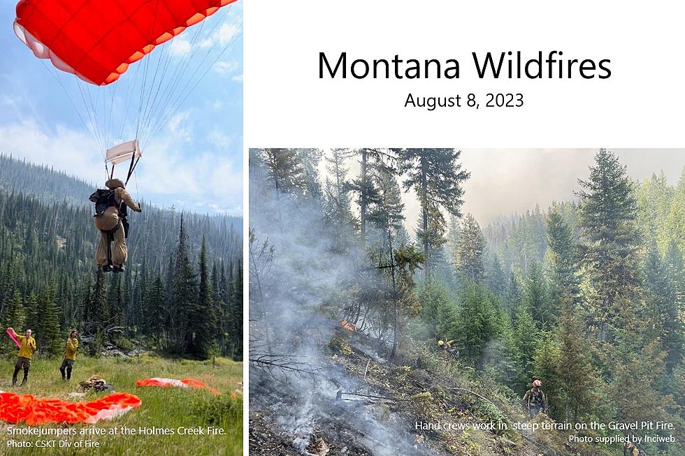
HOLMES CREEK FIRE
This is one of two new fires reported by the Confederated Salish & Kootenai Tribes Division of Fire. It is 45 acres, 70% contained, and burning on top of the Mission Mountain Range in steep rocky terrain. Staffed with smokejumpers and heli-repellers.
BIG KNIFE FIRE
Continued rain over the Big Knife Fire continues to moderate fire behavior and growth, primarily smoldering, creeping, and backing in the heavy fuels. Heavy equipment operators completed a mastication line along the fire's southwestern edge to reduce fuels and have started work mulching vegetation along Jocko Canyon Road. Firefighters continued holding and improving a strategic firing operation they conducted Friday and Saturday to keep the fire north of Agency Creek, and structure protection crews are assessing structures in the Jocko Canyon area. Aircraft are aiding firefighters as conditions allow, although limited visibility has hindered some air operations. Resource Advisors are working with fire managers to ensure cultural and natural resource values are evaluated and protected during suppression activities.
TIN SOLDIER COMPLEX
Hungry Horse Reservoir will be closed beginning August 8, 2023. All National Forest System lands in the area and FS Road #38 (East Side Road #38) and FS Road #895 (West Side South Fork Road #895) will be closed to public use for public and firefighter safety.
The Tin Soldier Complex is estimated at 2,631 acres in size and remains 0% contained. Fire activity Monday was minimal between the 3 fires. An IR flight detected an increase of 51 acres of growth across all three fires with Kah Mountain and Sullivan being the most active.
Current Acres burned as of the morning of August 8th.
- Bruce Fire – 993 acres at 0% containment
- Kah Mtn Fire – 407 acres at 0% containment
- Sullivan Fire – 1,208 acres at 0% containment
- Con Kelly Fire – 0.25 acres – Out.
Fuel breaks have been established around the Wilderness Lodge and the hydro-electric facility. Hose line and sprinklers have been set up around the Wilderness Lodge. Exposed wood on the hydro-electric facility was wrapped and sprinklers were installed along Addition Bridge. Fire personnel are continuing structure protection efforts for the Spotted Bear Ranch, Diamond R Ranch and the Spotted Bear Ranger Station compound. A safety zone has been established on the Spotted Bear Ranger Station compound. Crews will continue installing hose line and sprinkler systems around the Spotted Bear Ranch, Diamond R Ranch and the Spotted Bear Ranger Station compound. Fire personnel are developing a structure plan for the Heinrude residential community.
EAST FORK FIRE
Lightning is also to blame for this 850-acre fire, burning in heavy timber & subalpine fir on a ridge just west of the East Fork of Sunday Creek, approximately 12 miles south of Trego, MT. The fire was very active over the weekend, with group torching and spotting. The fire continues to spread on all sides, especially to the east, which is the most active side of the fire.
GRAVEL PIT FIRE
The human-caused Gravel Pit Fire is burning in heavy fuels on a mix of private and federal land located along Highway 2 near Houghton Creak and McGinnis Meadows Roads.
The fire showed minimal growth Saturday, with the size increasing to 304 acres. Over the weekend, crews attacked the northwest flank of the fire directly constructing direct handline along the fire edge. To the northeast, crews laid hose and plumbed lines to bring water to the fire in the future. Precipitation fell on the fire Sunday morning, which helped moderate fire behavior and allow crews good access to attack the fire directly. More rain is forecast for the area today (Monday).
STADIUM CREEK FIRE
The Stadium Creek Fire is burning on an east-facing slope in the Stadium Creek drainage between Gorge and Cannon Creeks; located within the Bob Marshall Wilderness on the Spotted Bear Ranger District.
An Incident Awareness and Assessment flight mapped the fire at 50 acres as of the morning of 8/4/2023. The fire has run up the ridgeline to the west of the original start and has been burning northward along the ridge toward the confluence of Stadium and Gorge Creeks. The Spotted Bear Ranger District will continue to monitor the fire and implement point protection strategies to any values at risk as necessary.
BLACK BUTTE FIRE
The 460-acre Black Butte Fire, located near the Missouri River in southern Blaine County, is now 70% contained.
More From KSEN AM 1150