Weekend Rains Helped, But the Firefight Continues
Mother Nature started most of the wildfires currently burning in Montana, and over the weekend, she gave firefighters a hand in dealing with many of them, providing welcome rain showers and cooler temperatures that dampened fuels and raised humidity in the area of some of the fires. Here is the latest on the major fires as of this morning:
SIDNEY FIRE
A lightning strike started the 100-acre Sidney Fire, which is 7-8 miles south of Highway 2 in the northwest tip of the Pondera County panhandle. Six firefighters are on scene. Nearby footprints from fires in 2007 and 2017 provide opportunities for fire management since fuels in these footprints are less dense and suppression actions are most likely to be effective.
The following trails are currently closed due to fire activity:
- Trail 101 from the junction of 101 and 133.
- Trails 133, from Summit Trailhead, and Trail 133.1, from -Summit Campground, to where these 2 trails join Trail 137.
- Trail 134 from Forest Road 8958 to the junction with Trail 137.
- Trail 137 from the Trail 133/133.1 junction to the Trail 137/101 junction.
- TTrail 136 which runs between Trails 101 and 137.
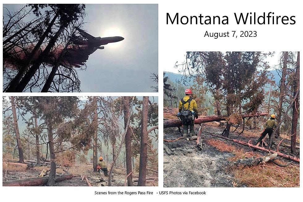
ROGERS PASS FIRE
This lightning-caused fire, 15-miles east of Lincoln, received about an inch of rainfall over the weekend. As of Sunday evening, it was still 46 acres, and 50% contained. The Continental Divide Trail has been reopened.
COLT FIRE
The Colt Fire, near Seely Lake, covers 7179 Acres as of Monday morning, and is 25% contained.
While rainfall in the fire area decreased fire activity, it also limited firefighters’ ability to access roads in certain areas of the fire. Crews were able to successfully “mop-up” residual heat from much of the fire’s northern and eastern edge. On the southwest corner of the fire, heavy equipment completed line construction up to Sunset Ridge and crews scouted beyond Sunset Ridge to identify additional areas to continue line construction. To the east, crews “mopped-up” residual heat along the fire’s perimeter and searched for any remaining areas of heat.
Crews will mop-up remaining residual heat along the fire’s north and east flanks. Heavy equipment will search for opportunities to construct line further along the fire’s southwest edge near Sunset Ridge. Hand crews will again be in the area, searching for a path to continue the line beyond the ridge. Along the southern edge of the fire crews will continue to construct handline above West Fork Clearwater River. Aircraft will be available to assist firefighters as needed and as conditions allow.
Within the last 24 hours, the fire received about 8/10 of an inch of rain. Showers and thunderstorms may return this afternoon, bringing with them a risk of heavy downpours, lightning, and gusty outflow winds. While the rain has lessened fire activity for the time being, fire activity is expected to increase later in the week as temperatures rise and relative humidities decrease. This incoming warm weather with possible gusty winds will increase the chances of larger fuels (between 3 inches and 8 inches in diameter) burning, as the dryness of these fuels is still near record lows.
RIDGE FIRE
There will be a Public Meeting today, August 7th, at 7:00 PM at the Glacier Bible Camp (400 5th St W). Personnel from the incident management team, forest service, and Flathead County Emergency Services will present about current fire information, closures, and evacuation information.
The Ridge Fire is currently at 2,773 acres, an increase of 189 acres.
The Ridge Fire is located 6 miles southeast of Hungry Horse, MT on the Hungry Horse Ranger District of the Flathead National Forest. The Ridge Fire is a full suppression fire and firefighters responded quickly using indirect tactics by creating fuel breaks along existing roads and natural features.
The fire is active on all sides with most active fire behavior occurring on the south and east sides of the fire. It is currently spreading north towards Hungry Horse Mountain and is burning in steep terrain with heavy dead and down fuels.
East Side Road #38 is closed to all public traffic east of the junction of FS Road 497 (Desert Mountain Road) and the East Side Road #38. The West Side South Fork Road #895 is currently closed to public travel near the 15 mile just past the Lid Creek Campground.
The West Side Road South Fork Road #895 will be closed starting tomorrow (August 8th) from the Hungry Horse Dam to the existing closure at mile 15, near the Lid Creek Campground.
Current priorities are to keep the fire east of private property near Martin City, Coram and Hungry Horse. Operations include implementing fuel breaks along FS Road 38 and utilizing heavy equipment near private property on the west. Additional operations include extinguishing spot fires and wrapping critical communication infrastructure such as electrical boxes that service Desert Mountain Communication Towers.
A Type 3 Incident Management Team (Northern Rockies Team 9) assumed command of the fire at 6:00 am on August 3.
NIARADA FIRE & MILL POCKET FIRE
The Niarada Fire continued to receive light precipitation over the weekend, further moderating fire behavior and allowing crews more opportunities to construct direct fire lines immediately adjacent to the fire in some areas. Additionally, a large complement of engines and hand crews arrived Sunday to help bolster suppression efforts. Firefighters continued working to secure lines along Cromwell Creek Road on the fire's northeastern perimeter, cooling hotspots and mopping up inward from control lines approximately 15-20 feet. Crews also continued assessing and preparing structure protection measures outside Elmo towards Big Arm. However, heavy fuels and steep terrain still hamper direct containment in certain areas along the fire's southeastern perimeter. Fire managers are shifting some crews from other areas of the Niarada and Mill Pocket fires to the southern and eastern sides of the fire to prepare for potential firing operations over the next few days. These operations reduce fuels between firelines and the active fire edge, helping to build a fuel break along the constructed line. Firefighters working the Mill Pocket Fire continue to improve constructed firelines, and much of the line is secure enough to consider the fire approximately 35% contained. However, work continues on the northwestern edge.
MIDDLE RIDGE FIRE
West of Ronan, the Middle Ridge Fire was measured Sunday evening at 12,700 acres, with 51% containment, according to the Confederated Salish and Kootenai Tribes Division of Fire. The fire is burning in timber, grass and pinyon-juniper .Smoke may still be visible inside the fire containment line where the fire is still smoldering.
BIG KNIFE FIRE
Continued rain over the Big Knife Fire continues to moderate fire behavior and growth, primarily smoldering, creeping, and backing in the heavy fuels. Heavy equipment operators completed a mastication line along the fire's southwestern edge to reduce fuels and have started work mulching vegetation along Jocko Canyon Road. Firefighters continued holding and improving a strategic firing operation they conducted Friday and Saturday to keep the fire north of Agency Creek, and structure protection crews are assessing structures in the Jocko Canyon area. Aircraft are aiding firefighters as conditions allow, although limited visibility has hindered some air operations. Resource Advisors are working with fire managers to ensure cultural and natural resource values are evaluated and protected during suppression activities.
TIN SOLDIER COMPLEX
The Tin Soldier Complex was originally made up of 4 fires burning in timber litter with heavy dead and down fuels. The Tin Soldier Complex is located on the Spotted Bear Ranger District of the Flathead National Forests, approximately 17 miles east of Swan Lake. The fires associated with the Tin Soldier Complex started by lightning on Saturday, July 30th. Past fire activity has included torching, spotting, and active consumption of heavy fuels.
Current Acres burned as of the morning of August 6th.
- Bruce Fire – 977 acres at 0% containment
- Kah Mtn Fire – 304 acres at 0% containment
- Sullivan Fire – 1,087 acres at 0% containment
- Con Kelly Fire – 0.25 acres – Out.
The Tin Soldier Complex is estimated at 2,368 acres in size and remains 0% contained. Fire activity Saturday was low between the 3 fires.
Fuel breaks have been established around the Wilderness Lodge and the hydro-electric facility. Hose line and sprinklers have been set up around the Wilderness Lodge. Exposed wood on the hydro-electric facility was wrapped and sprinklers were installed along Addition Bridge. Fire personnel are continuing structure protection efforts for the Spotted Bear Ranch, Diamond R Ranch and the Spotted Bear Ranger Station compound. A safety zone has been established on the Spotted Bear Ranger Station compound. Crews will continue installing hose line and sprinkler systems around the Spotted Bear Ranch, Diamond R Ranch and the Spotted Bear Ranger Station compound. Fire personnel are developing a structure plan for the Heinrude residential community.
EAST FORK FIRE
Lightning is also to blame for this 850-acre fire, burning in heavy timber & subalpine fir on a ridge just west of the East Fork of Sunday Creek, approximately 12 miles south of Trego, MT. The fire was very active over the weekend, with group torching and spotting. The fire continues to spread on all sides, especially to the east, which is the most active side of the fire.
GRAVEL PIT FIRE
The human-caused Gravel Pit Fire is burning in heavy fuels on a mix of private and federal land located along Highway 2 near Houghton Creak and McGinnis Meadows Roads.
The fire showed minimal growth Saturday, with the size increasing to 304 acres. Over the weekend, crews attacked the northwest flank of the fire directly constructing direct handline along the fire edge. To the northeast, crews laid hose and plumbed lines to bring water to the fire in the future. Precipitation fell on the fire Sunday morning, which helped moderate fire behavior and allow crews good access to attack the fire directly. More rain is forecast for the area today (Monday).
STADIUM CREEK FIRE
The Stadium Creek Fire is burning on an east-facing slope in the Stadium Creek drainage between Gorge and Cannon Creeks; located within the Bob Marshall Wilderness on the Spotted Bear Ranger District.
An IAA (Incident Awareness and Assessment) flight mapped the fire at 50 acres as of the morning of 8/4/2023. The fire has run up the ridgeline to the west of the original start and has been burning northward along the ridge toward the confluence of Stadium and Gorge Creeks. The Spotted Bear Ranger District will continue to monitor the fire and implement point protection strategies to any values at risk as necessary.
BLACK BUTTE FIRE
The 460-acre Black Butte Fire, located near the Missouri River in southern Blaine County, is now 70% contained.
More From KSEN AM 1150